3D Aerial View Rendering Services


Ourpartners


Have a project?
We have ideas to discuss!
We create sharp, tailored 3D aerial renderings that show how your project fits, functions, and communicates in its real-world context. Architecture, site, and story come together in clean, elevated compositions that cut through noise and speak with purpose.
Types of 3D Aerial View Rendering Services
3D aerial view rendering services offer a comprehensive perspective of architectural projects, combining realistic representation with a unique perspective that helps both professionals and prospective buyers grasp the full scope of a design. Whether for real estate marketing, stakeholder decision making, or communicating complex projects, CYLIND, as a professional rendering company, can create aerial view renderings that enhance visual appeal and provide valuable insights for informed decisions.
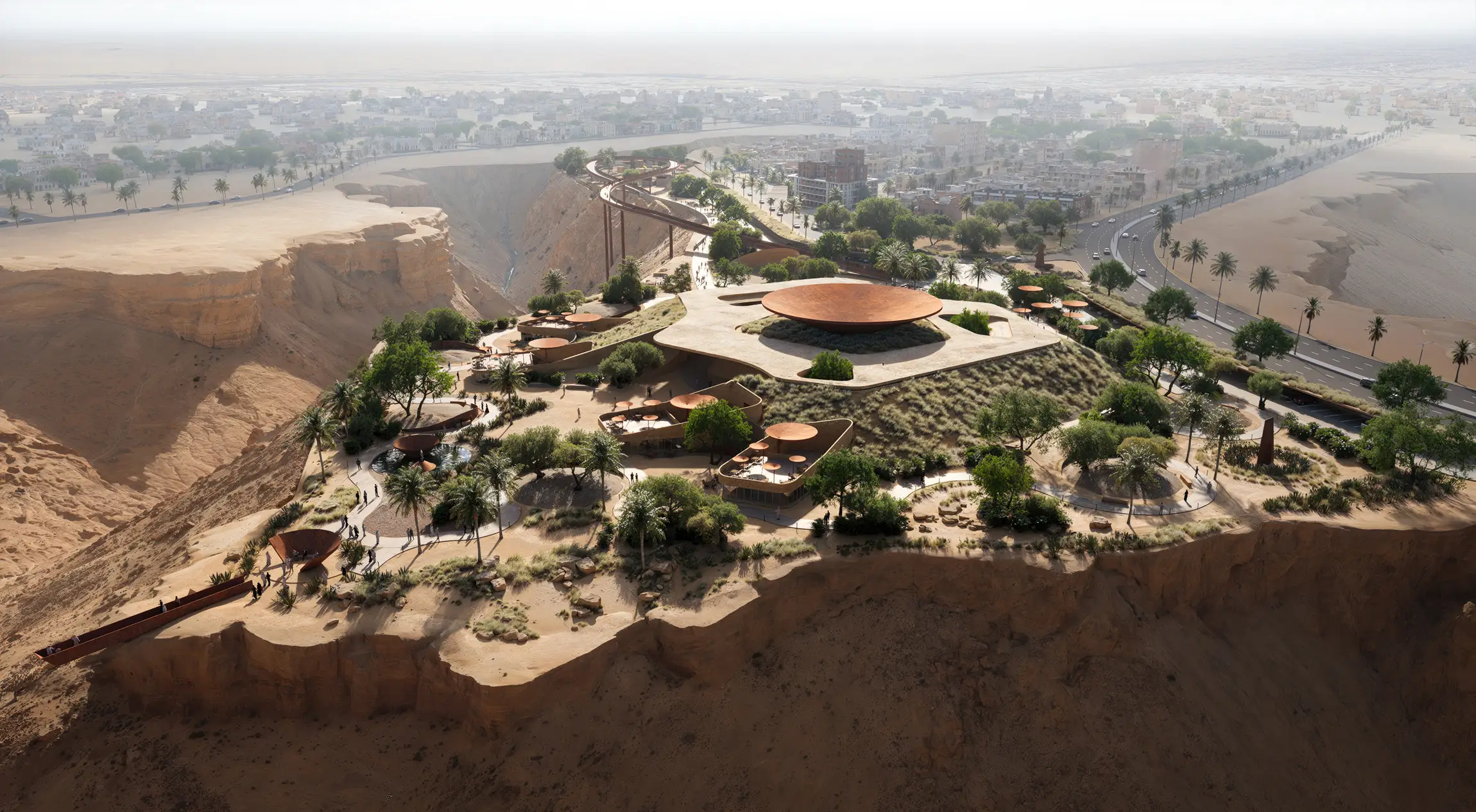
3D Aerial Site Visualizations
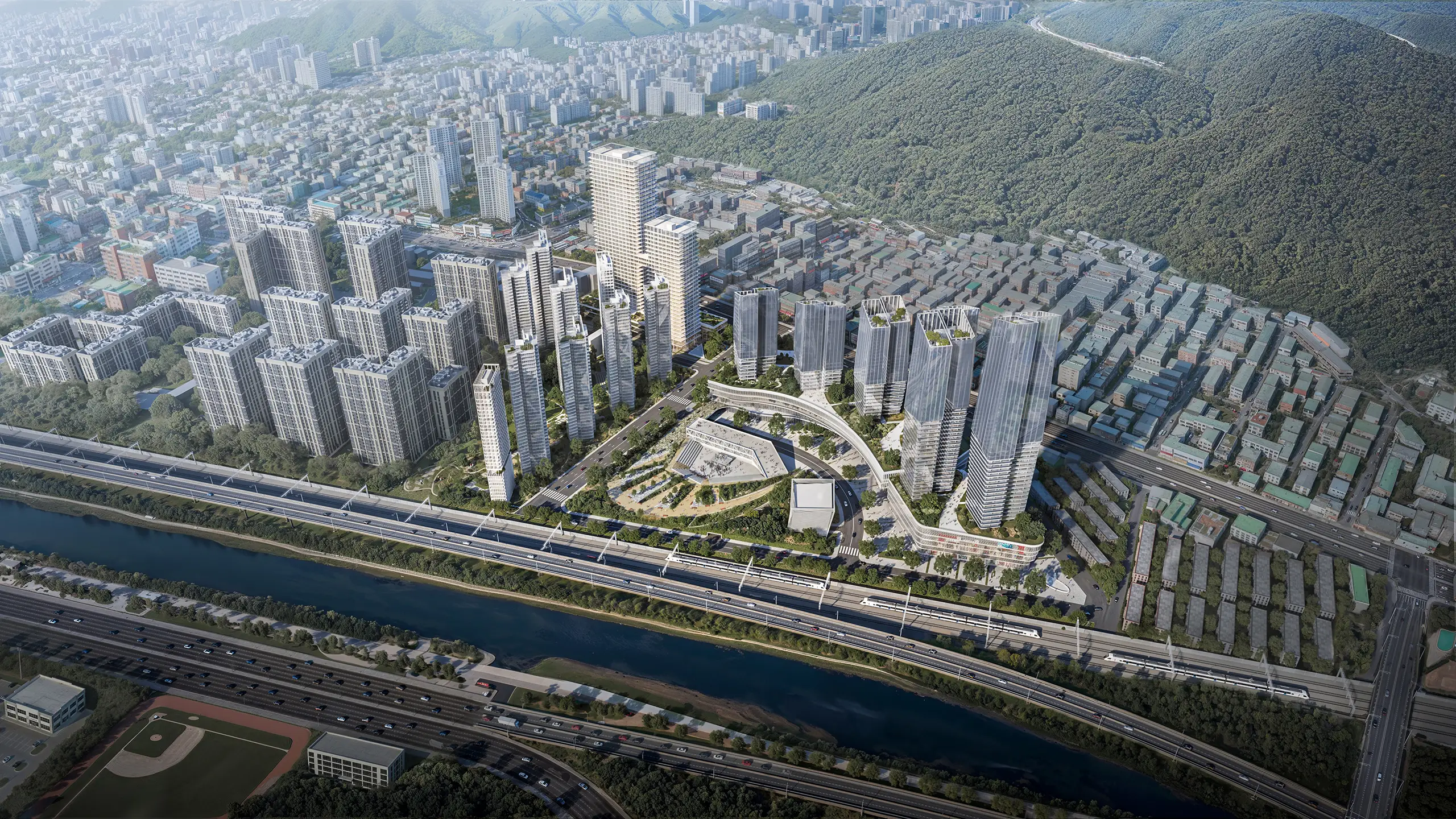
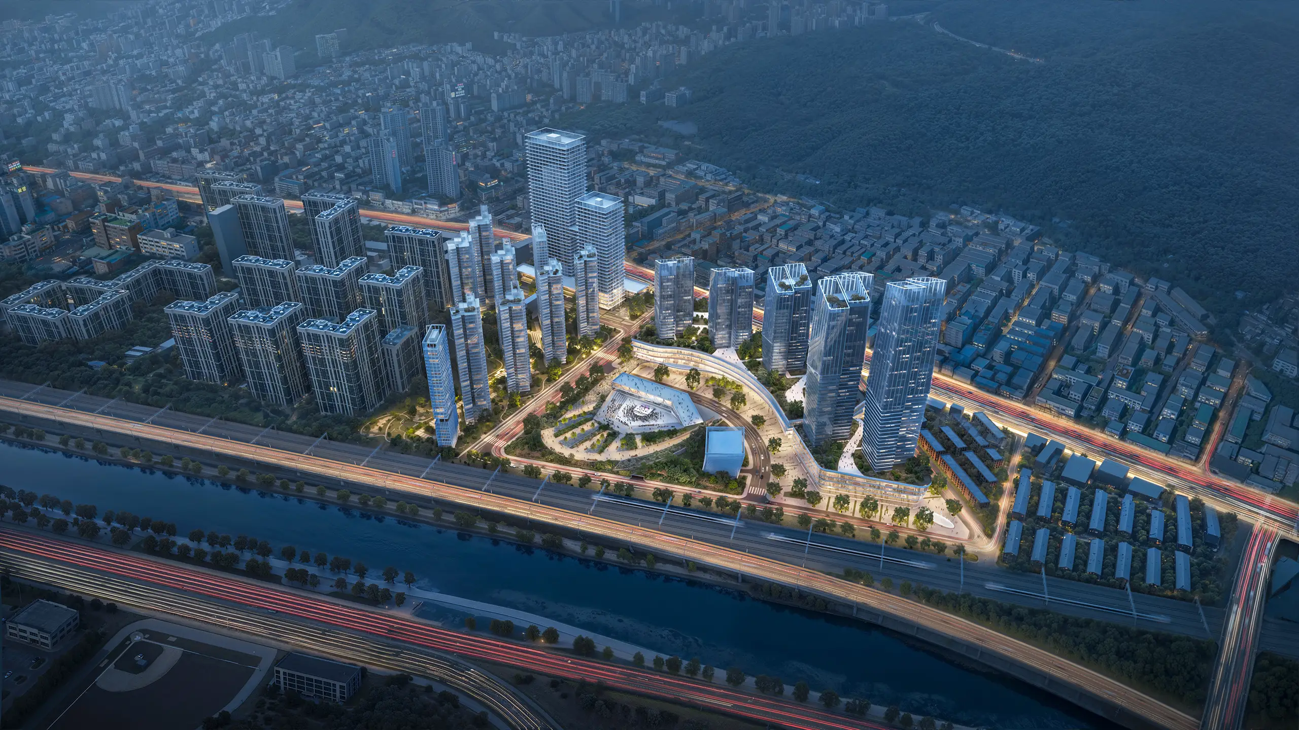
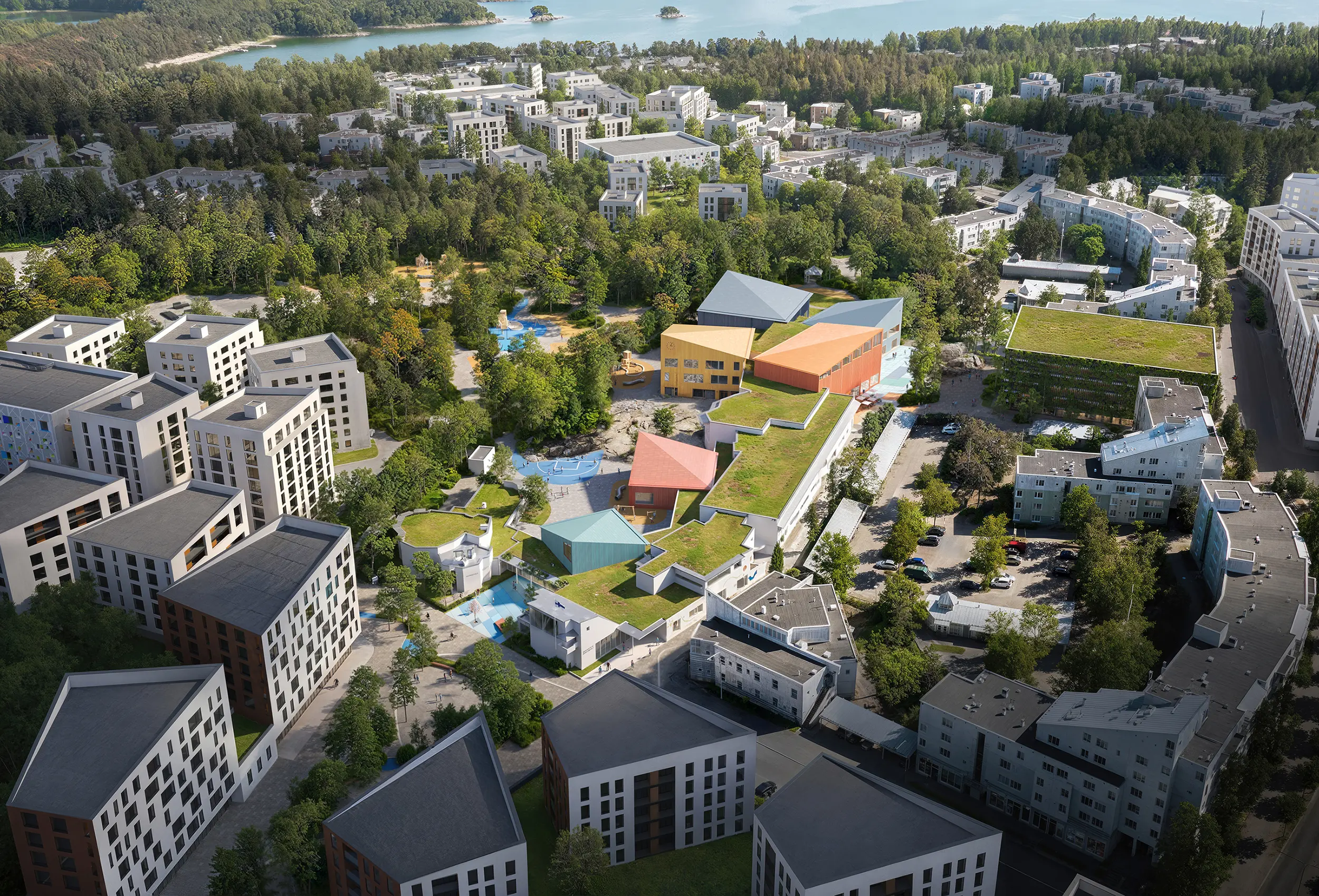
3D aerial site visualizations deliver a comprehensive overview of the surrounding landscape, spatial relationships, and urban context, giving planners and developers a clear understanding of site conditions. These conceptual aerial rendering assets are essential for new developments, helping identify opportunities and challenges before construction begins. Paired with 3D Site Plan Rendering Services, they strengthen visual communication and support feasibility analysis, zoning, and early design alignment.
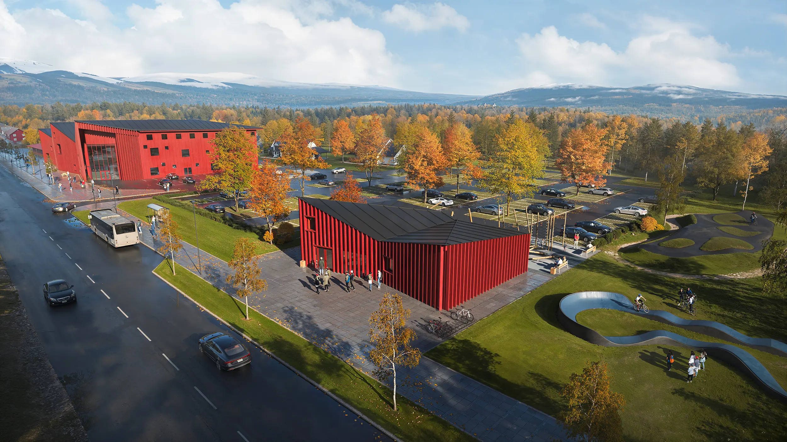
Architectural Aerial Renderings
Architectural aerial renderings integrate the building into its surrounding buildings and landscape design, showing how it relates to commercial spaces, residential complexes, and public areas. This realistic representation makes them ideal for project presentations to investors, municipalities, and potential clients. For enhanced aesthetic appeal and to elevate the surrounding environment, our 3D Landscape Rendering Services complement aerial views by focusing on ground level shots and green space integration, ensuring the design concept harmonizes with its urban context.
Key Aspects of Aerial Rendering
Different aerial rendering types expand the possibilities of architectural visualization, whether it’s drone renderings, interactive aerial rendering, or producing high quality images with a realistic representation of the site. Such perspectives convey a comprehensive view of a single future building or grand scale development, showing its spatial relationships with the surrounding buildings and landscape. This level of detail gives architects, developers, and new clients the clarity they need for informed decisions at any stage of the project.
Bird’s-Eye View Perspective
Understanding how a project sits within its environment is critical, yet often difficult to grasp in early stages. A bird’s-eye view provides clarity, offering a full spatial overview that helps stakeholders evaluate access, adjacency, and impact with ease. See Bird Eye View Rendering Services for technical insight and applied solutions.
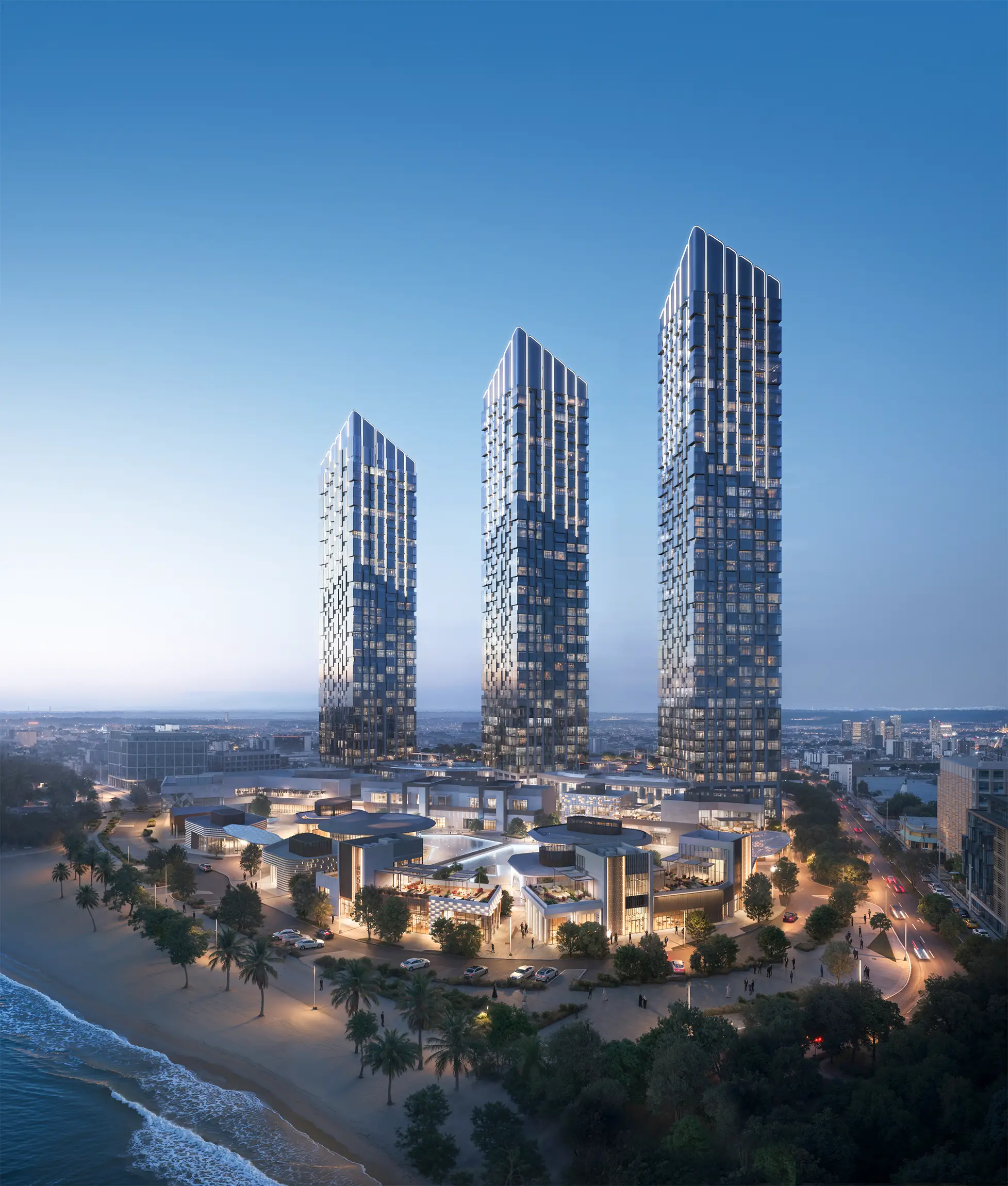
Photorealistic Aerial Renderings
Photorealistic aerial renderings deliver precise spatial and material accuracy. They support confident evaluation, help align stakeholders, and accelerate design approvals in both technical and presentation contexts.
Early Design Visualization
Planning teams need the confidence to move forward without hesitation. Early-stage aerial views reveal hidden design conflicts and spatial inconsistencies, enabling teams to refine their designs before risks become real costs.
Improved Visual Communication
Miscommunication between technical and non-technical teams is a common roadblock. With clear, shared visuals, 3D architectural aerial renderings bridge disciplines and ensure alignment across all parties involved, from designers to decision-makers.
Real Estate Marketing Advantages
In real estate marketing, a rendering company can provide an aerial view render that high-impact marketing asset, conveying the full potential of a property in a single frame. They present layout, landscape, and development context with precision, enhancing perceived value, strengthening brand presence, improving campaign performance across investors and new clients, and attracting potential buyers.
Urban Planning & Visualization
Urban plans often involve layers of complex information. Aerial render simplifies that complexity, turning raw data into accessible visuals that help planners communicate intent and secure stakeholder engagement with clarity and trust.
Benefits of 3D Aerial Rendering for Different Sectors
3D aerial rendering serves multiple fields such as real estate marketing, urban planning, commercial developments, and complex projects. It highlights how a design relates to its urban context and surrounding landscape, helps stakeholders make informed decisions, and ensures clear visual communication throughout the project.
Aerial Renders for Real Estate Design and Sales
3D aerial renders are tailored to meet the visual and analytical needs of various real estate segments, including residential masterplans, commercial sites, hospitality assets, and mixed-use developments. As part of a broader suite of Real Estate 3D Rendering Services, these visuals bring together site orientation, access points, landscape, and infrastructure into a single, coherent frame. This enables marketing and sales teams to present development value with clarity, support investment pitches, and differentiate assets in competitive markets. This cross-scale visualization strategy is further strengthened by 3D Floor Plan Rendering Services, which deliver interior-level precision and support both early design development and asset positioning for sales.
Streamlined Collaboration Using Aerial Renderings
The 3D aerial rendering provides a unified spatial reference that all project stakeholders can interpret consistently. Aligning aerial perspectives across architecture, engineering, and development teams early in the workflow facilitates real-time decision-making, reduces ambiguity in design interpretation, and minimizes the risk of rework during execution.
High-Quality Property Presentation Through Aerial 3D Views
Aerial view render enhances high-end property presentations by integrating massing, circulation, orientation, and landscape context into a unified visual asset. They help resolve typical barriers in real estate communication—such as limited site legibility, unclear urban relationships, and disconnected messaging—by providing a structured spatial overview aligned with both design integrity and marketing objectives. The result is a technically informed, visually cohesive realistic images that supports valuation, investor outreach, and architectural narrative.
Additional Benefits of Aerial 3D Rendering
Beyond its core role in showing projects from above, aerial 3D rendering offers practical advantages that influence the entire development cycle. It helps reveal design issues early, strengthens the visual impact of presentations, reduces costs compared to traditional methods, and speeds up evaluations by giving stakeholders clear, accessible information.
Improved Design Clarity & Flaw Detection
Early-stage architectural visualization allows teams to refine the design concept before investing in detailed work. By using conceptual aerial rendering or interactive aerial rendering, it becomes easier to identify conflicts in spatial relationships, assess the surrounding landscape and surrounding buildings, and ensure the future building fits the intended urban context.
Enhanced Presentations and Visual Materials
High-quality imagery enhances presentations for both private and public projects, showing scale, proportions, and the qualities that make a design stand out. Such visual materials as 3D aerial renderings support presentations to investors, buyers, and decision-makers by conveying intent with accuracy and impact.
Cost-Effective Visualization Tool
Efficient visualization workflows cut expenses by minimizing the need for physical mock-ups, repeat site visits, or extensive field analysis. Digital outputs can represent anything from compact plots to extensive developments, providing the necessary perspective for evaluation.
Time-Saving Evaluation Method
Clear, accessible visuals accelerate approval processes and keep all participants aligned. By delivering a complete picture of the project’s context, they help stakeholders move forward with confidence and reduce the risk of costly revisions later.
Why Choose Our 3D Aerial Rendering Studio
Clients choose CYLIND for aerial 3D rendering when accuracy, design intelligence, and market relevance are critical.
Senior-Level Aerial Rendering Expertise
With over 9 years of experience delivering aerial 3D renderings across North America, Western Europe, the Middle East, and Southeast Asia, our team has partnered with real estate developers, leading architecture studios, and urban planning consultancies to visualize large-scale masterplans, hospitality assets, commercial complexes, and civic infrastructure. Every 3D artist on our visualization team has a professional background in architecture, allowing them to interpret project briefs through a design-conscious lens. This combination of visual craft and architectural fluency ensures that each aerial rendering combines visual clarity with technical depth.
On-Time Delivery for Complex Projects
At CYLIND, a dedicated project manager oversees the rendering workflow, which guarantees timelines are met, feedback loops are efficient, and communication stays clear throughout. This structure supports reliable delivery without compromise on visual quality or architectural precision.
Client-Focused Rendering Process
We approach every project as a collaboration. Through active listening, feedback integration, and a structured review cycle, we ensure the final renderings truly reflect the vision.
3D Aerial Rendering Workflow: From Concept to Delivery
Initial Briefing and Vision Alignment
We begin with an in-depth consultation to understand the objectives, context, and audience. This sets the direction for a focused and effective aerial rendering strategy that supports marketing strategy and property marketing goals.
Rendering Development: Building the Aerial Scene
Our team combines architectural data, reference materials, satellite imagery, and design input to craft a scene that is both technically accurate and visually compelling. This can include drone photography or drone footage and contextual details that enhance the realism of the aerial scene rendering.
Reviewing and Refining the Aerial Renders
We implement the feedback through structured review cycles — refining lighting, scale, camera angles, and spatial clarity until the vision is fully realized. The rendering process is supported by our dedicated team and guided by the project details.
Final 3D Aerial View Rendering Delivery
Clients may receive a ready-to-use final aerial view rendering, which can be in the form of a high-resolution image, an animation, or a virtual reality visualization, tailored to the specific platform or marketing campaign.
Applications of 3D Aerial Rendering
Residential Development Aerial Views
Aerial renderings of residential developments reveal spatial and market dynamics across typologies from low-density private housing and perimeter blocks to vertical living formats and mixed-use urban clusters. By integrating data on circulation, view corridors, landscape edges, and proximity to amenities, these visuals support early design validation, site strategy, and positioning for investor or buyer segments.
Commercial Project Visualization
Commercial real estate encompasses a wide range of spatial programs, retail anchors, corporate campuses, distribution centers, transit-oriented nodes, and hospitality venues. Aerial renderings clarify how these components align with circulation logic, access hierarchies, public realm activation, and site-specific adjacencies, supporting design feasibility and investment positioning.
Infrastructure Project Integration
Aerial renderings provide an integrated view of transportation corridors, service infrastructure, and their relationship to the urban fabric, helping stakeholders evaluate connectivity, capacity, and land use alignment at scale.
Urban Planning and Aerial View Analysis
Bird’s view renderings support urban planning by visualizing zoning structures, street hierarchies, land use density, and development phasing in a unified frame. They allow for rapid evaluation of planning options, visibility of spatial constraints, and alignment with environmental impact and regulatory logic.
3D Aerial Rendering Pricing
Each project is unique, and our pricing reflects that. No matter the scale or stage of the project — from early concepts to polished final visuals — we tailor each quote to match the needs, complexity, and timeline. Contact us directly to discuss the project.


FAQS
How does your 3D aerial view rendering company manage the feedback loop and ensure that revisions are implemented efficiently without compromising deadlines?
After presenting initial drafts of aerial renders in 3D, we encourage clients to provide detailed feedback, which we carefully review and categorize for clarity. Our team typically allocates specific timeframes for revisions, ensuring that changes are made promptly while maintaining quality. A dedicated manager is assigned to each project, constantly communicating with the client to track progress and address concerns in real-time.
How does your firm manage project timelines, and what measures are in place to ensure milestones are met?
We utilize project management tools to set clear timelines and track progress, allowing us to identify potential bottlenecks early. Regular check-ins and updates keep everyone aligned on goals and deadlines, while our manager ensures that milestones are met without compromising the quality of our work.
Are there any caps on the number of revisions included in your initial quote, and how does your agency handle additional revision requests?
In our standard workflow and pricing, we include up to three revision sessions to allow clients the flexibility to make necessary adjustments at no extra cost. If additional revisions are needed beyond those sessions, we’re happy to accommodate them for an agreed-upon fee. This approach ensures clients can refine their vision while keeping the project within budget. Our flexible workflow and skilled team enable us to adapt quickly to tight deadlines or expand scope as necessary. A dedicated project manager assesses resources and adjusts timelines to ensure we uphold our quality standards while meeting client expectations. We have a team of 3D artists, allowing us to bring in additional resources when needed to ensure quality and timely delivery.
What types of files or reference materials should I provide for a successful 3D aerial rendering project?
We recommend providing CAD drawings (DWG/DXF), site plans, architectural models (Revit/SketchUp), landscape concepts, and any drone or satellite imagery if available. Additional useful materials include GIS data, zoning information, and contextual photos.
In which formats will the final 3D aerial renderings be delivered?
Final architectural renderings are typically provided in high-resolution JPEG, PNG, or TIFF formats for static images, and MP4 or MOV for animation. Interactive assets can be delivered in formats suitable for web or VR platforms (e.g., WebGL, Unreal, Unity).
Can 3D aerial renderings be integrated into interactive or VR presentations?
Yes. We offer VR-compatible outputs and interactive scene exports that can be used in virtual walkthroughs, marketing kiosks, or real-time planning tools. Let us know your preferred platform or presentation goals during the briefing stage. It is customized based on project size, scope, and deadline. We offer flexible pricing to suit early concepts or final polished presentations. Deliverables range from static imagery to animated flythroughs or VR-ready assets, all created using advanced computer generated visualization techniques to ensure high accuracy, realism, and smooth integration with your chosen medium.